دانلود لایه 12 کلاسه بافت خاک کشور ایران
توجه: تمامی مطالب این صفحه از یک منبع معتبر اخذ شده است.
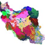
Soil texture classes (USDA system) for soil depth 200 cm at 250 m
sol_texture.class_usda.tt_m_250m_b200..200cm_1950..2017_v0.2
Soil texture classes (USDA system) for standard soil depths 200 cm at 250 m. Derived from predicted soil texture fractions using the soil texture package in R. Processing steps are described in detail here
To access and visualize maps use: OpenLandMap.org
:If you discover a bug, artifact or inconsistency in the maps, or if you have a question please use some of the following channels
- Technical issues and questions about the code: https://gitlab.com/openlandmap/global-layers/issues
- /General questions and comments: https://disqus.com/home/forums/landgis
:All files internally compressed using “COMPRESS=DEFLATE” creation option in GDAL. File naming convention
- sol = theme: soil
- texture.class = variable: soil texture class
- usda = determination method: USDA texture triangle
- c = factor
- 250m = spatial resolution / block support: 250 m
- b200..200cm = vertical reference: 200cm depth below surface
- 1950..2017 = time reference: period 1950-2017
- v0.2 = version number: 0.2
………………………………………………………………………………………………………………………………………………………………………………….